|
MAGLEV'S
RELEVENCE TO WESTERN MELBOURNE
Transporting Melbourne
A Maglev vision
for Melbourne and focus of this proposal, is founded on the Victorian
Government�s integrated transport and landuse vision.
Maglev in
arriving at this point has developed a comprehensive understanding of the
transport and urban context, reflected in planning strategies by the
Department of Infrastructure.
Transporting
Melbourne and Transporting Victoria in particular have given us insights into
the Melbourne transport and landuse framework.
Services based
on the Geelong to Melbourne Corridor provide an opportunity to greatly add to
accessibility throughout the whole North Western Metropolitan region and Geelong
Corridor.
Our vision,
however extends our fit to central and northern regional Victoria in addition to
the Greater Melbourne area.
This present
proposal by Maglev is to add quick limited stop services which when integrated
with existing transport systems, improves access for Melburnians in the
following priority corridors:
- Geelong Transport Corridor
- Airport Transport Corridor
- Metropolitan Orbital Transport Corridor
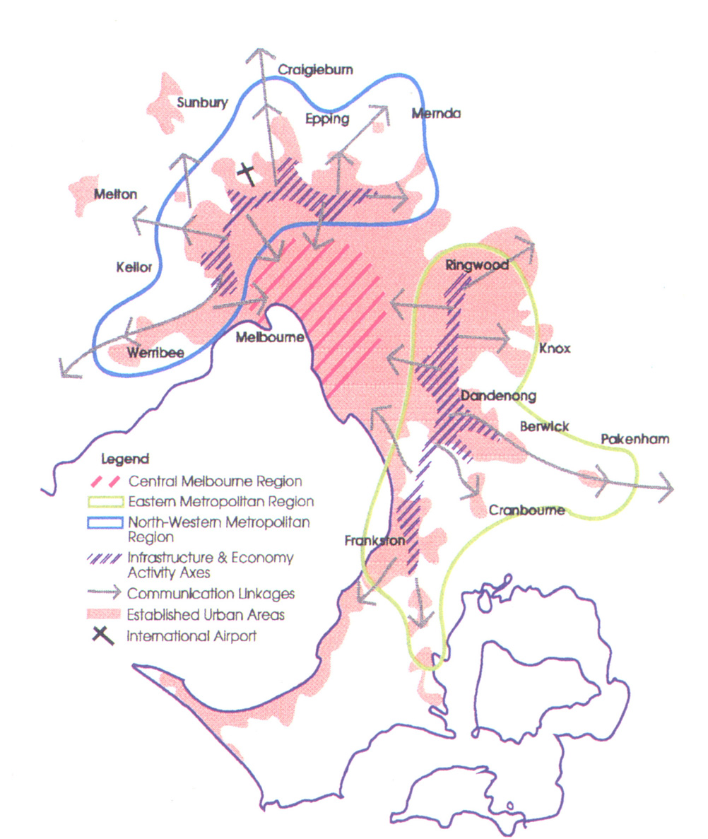
Melbourne�s
development up until the 1950�s was mostly along radial tram and train routes,
extending out from the City Centre. Since then, development has been more
influenced by road access, resulting in the spread of development beyond these
original corridors. Growth corridors outwards along a number of major road and
rail routes continue to be characteristic of Melbourne�s urban development.
There are five major growth corridors in subregions to the South East and North,
through to the South West outer areas of Melbourne.
Today,
Melbourne can be partitioned into a Central Region, Inner, Middle and Fringe
Suburbs. Overall, the road system is a good grid based system of arterial roads.
Some gaps exist in middle and fringe suburbs. Congestion occurs in the inner to
middle suburbs.
Both the
Central Region and Inner Suburbs have an extensive and well integrated rail,
light rail and tram network. Accessibility to this transport network is good in
these suburbs. About half of trips in the Central Region are by public
transport. The Central Business District is the single biggest generator of
trips in Melbourne.
The Inner
Suburbs is seeing the development of a band of support industries to the
increasingly �head office� and service industry nature of the CBD.
The Fringe
Suburbs contribute to around 30% of all trips. A lower density has been a
characteristic of these suburbs. Attention is now on rail links for radial trips
into the CBD and road links to the Metropolitan Orbital Transport Corridor for
orbital trips to destinations in the activity axes of the Middle Suburbs. Maglev
services have a strong fit to this transportation role.
The Middle
Suburbs were designed around car transport, although they are also serviced by
radial train lines from Melbourne. These are areas characterised by infill
development away from these train corridors, with limited access to public
transport for door to door trips. Around 50% of all trips start and end in these
suburbs.
Many of these
trips are orbital trips from one middle suburb to another. Key Government
objectives are to establish a Metropolitan Orbital Transport Corridor through
these suburbs, strengthen connecting bus services and provide an integrated
transport system focused on major activity centres. These Centres are developing
in the Activity axes shown below.
The high cost
of Inner suburb and CBD space is seeing the relocation of manufacturing and data
processing industry out to these middle suburbs.
In the south
east a rapidly growing employment and commercial base is developing between the
axis from Ringwood to Frankston.
In the north
and west the activity axis contains manufacturing, emerging technology and
science orientated industry. It is also developing as a warehousing area because
of proximity to transport corridors , the Port of Melbourne, Dynon Road Rail
Terminal and Melbourne Airport.
Maglev proposed
services that combine with existing transport to give door to door travel times
comparable to car. This will significantly improve transport choice for
Melburnians. It is our expectation that many current car trips will shift to
public transport, with the consequential contribution to environmental
sustainability and transport efficiency.
There is
confidence that this proposal will strongly fit the expectations of the
Victorian Government�s integrated transport investment appraisal framework.
EXTENSIONS
Extension of
services from Melbourne Airport to the Broadmeadows corridor permits extension
of the orbital services along the full length of the North Western Activity
axis. The accessibility improvements gained will provide good support for the
land use interactions forming in and around the northern arc of the orbital
corridor.
Maglev services
could similarly fit radial and orbital transport strategy in the Eastern
Metropolitan Region. The Eastern Transport Corridor, Scoresby Transport Corridor
and link towards Latrobe Valley are specific possibilities. Adding both system
capacity and public transport access for all Melburnians.
In the case of
the Scoresby Transport Corridor, the favoured development option contained the
establishment of priority line haul and improved feeder bus services. Maglev
services could integrate with these services and provide an alternative to
triplication of radial rail line sections on the Dandenong or Ringwood
corridors.
A radial link
from the Eastern Metropolitan Region linking via the CBD to the proposed North
Western Region Maglev system would enable through services to be operated. This
would further increase accessibility between both Activity axes and population
centres right across Melbourne. |